
Fort McMurray fire interactive map: NASA data shows fire invading town
Fort McMurray fire interactive map: NASA data shows fire invading town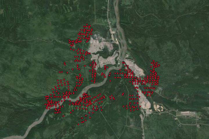
‚Perfect storm‘ of El Niño and warming boosted Alberta fires

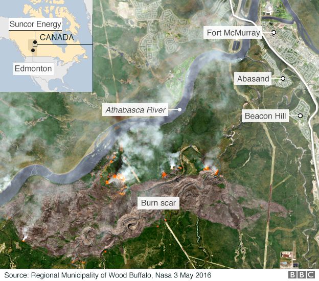
A satellite image of the fire, now deemed „extreme“ by the Alberta Agriculture and Forest service
„We’ve had an incredibly dry winter, we didn’t have enough snow pack,“ said Prof Judith Kulig from the University of Lethbridge in Alberta, who believes a „perfect storm“ of factors, including El Niño, has come together to cause the huge fire.
„This year the fire season officially began March 1st, last year it was March 15th. These are significant changes when the fire season used to begin in May and now begins in March.“
That fingerprint of El Niño saw Fort McMurray record a temperature of 32.6C earlier this week, which is significantly above the normal high temperature for early May of around 14C.
Not local but global
Many researchers believe that El Niño was not the only factor increasing the likelihood of a major fire in Alberta.
They point to the bigger global picture of rising temperatures, which in the first four months of this year are running more than 1C above the long-term average.
In January a Canadian study suggested that warming would lead to a „higher frequency of extreme fire weather days“ across the country.
The author of that paper, Dr Mike Flannigan from the University of Alberta, seems in little doubt that climate change was at least partly responsible for the outbreak around Fort McMurray.
„This is consistent with what we expect from human-caused climate change affecting our fire regime,“ he told reporters.
A number of research papers have highlighted the fact that warming is leading to an increase in wildfire risk. Studies have also shown that northern latitudes are feeling those impacts more strongly.
„Some of the changes can be ascribed to improvements in reporting but there are datasets which show the fire season has lengthened,“ said Prof Martin Wooster, from King’s College, London.
„There have been papers that have shown that not only in theory the conditions are there for longer, but also the actual area of burn has increased over the past half century.“
„That sort of thing is more likely to be able to be said in Canada than in other places.“
One factor that is often overlooked in the race to discover the causes of natural disasters is demography.
Just before the last major El Niño in 1997, the population of Fort McMurray was just over 30,000. The last census indicated it was over 60,000.
More people means not just a greater impact when fires occur, it also suggests the chances of one starting are increased.
„There is this thing called the wild land urban interface, which is where people’s homes get increasingly close to environments still undeveloped – and fire is able to come out of these ’natural‘ areas,“ Prof Wooster said.
„And if you get more people you are more likely to get ignitions.“
Ingrid und Les wohnen im Bezirk Eagles Ridge Richtung Timberlea. Diese Gegend ist bisher nicht vom Feuer betroffen:

Fort McMurray Mai 2016: vom Feuer betroffene Stadtbezirke nördlich des Atabascan River sind mit roten Punkten versehen.

Fort McMurray – Bezirk Eagles Ridge in dem Ingrid und Les ihr Haus haben.